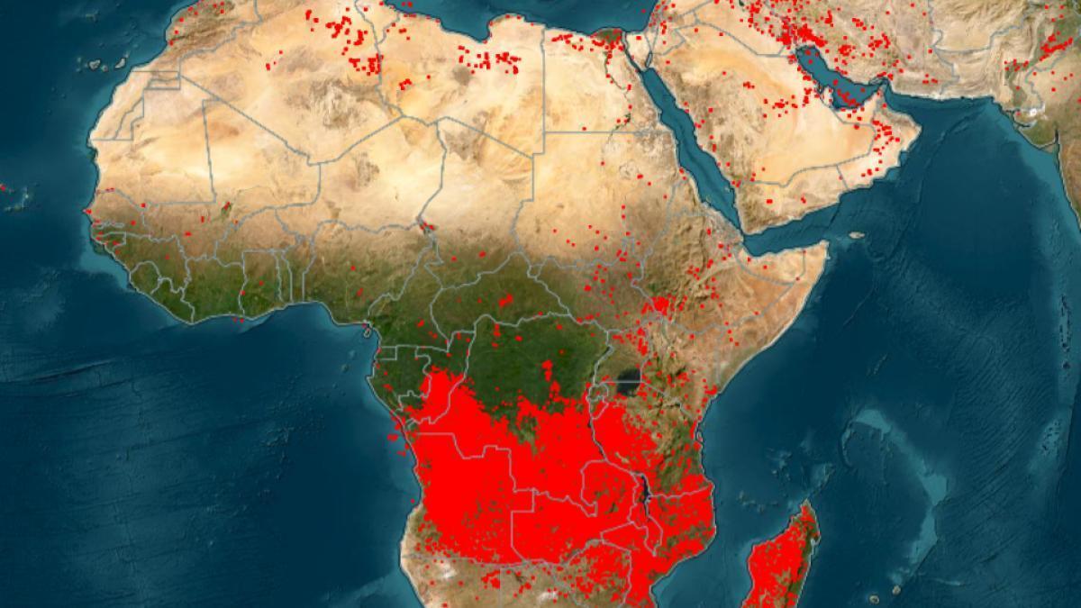
Africa-Press – Malawi. On the map from a local source monitoring ongoing fires worldwide, a large red spot covers central and southern Africa, resembling extensive fires in the Democratic Republic of the Congo, Angola, Zambia, Tanzania, and Malawi. However, this phenomenon “is not related to the destructive fires seen in Europe or North America,” as most of these fires are intentionally set.
Pixel Size
Satellites only detect “thermal anomalies,” meaning hot spots on the ground. Therefore, according to a local source, a small field fire covering only a few dozen square meters is represented by a red dot the same size as that of a vast fire. With millions of farmers igniting small plots simultaneously, it appears as one massive fire.
NASA confirms this explanation, stating that the operations manager of the system hosting the fire monitoring system says, “Regardless of how large or small the fire is, we must make the drawn pixel size large enough to appear on the map… But if you zoom in enough, you will see the individual fire pixels.” The accuracy of the MODIS sensor is one square kilometer per pixel, so if the fire is smaller, it is drawn as one square kilometer, leading the agency to conclude that these representations “can only be used to estimate the approximate location of the fire.”
This relates to an ancient agricultural technique known as slash-and-burn farming, where farmers and herders cut plants, leave them to dry, and then set them on fire to clear land of crop residues, enrich the soil with ash that becomes natural fertilizer, and stimulate the growth of tender grass for livestock. A local source describes these bush fires as “low-intensity fires that burn short grasses and shrubs in wooded savannas, advancing quickly and extinguishing rapidly.”
Record Low Season
A report titled “Africa Fire Situation 2025-2026,” released in June by a research team from a local university, states that Africa accounts for about 70% of the globally burned area and 50% of carbon dioxide emissions related to fires, mostly in savanna and grassland systems, as fire is part of an ancient and relatively climate-friendly ecological cycle.
It adds that the burned area and emissions “reached their lowest levels in the satellite record” during the 2025-2026 season, with southern and central Africa experiencing significant declines, while only Angola, the Democratic Republic of the Congo, the Republic of the Congo, Gabon, and Zambia saw slight increases. The Copernicus service confirms that the global decline over two decades is linked to “a decrease in savanna fires,” while the European Union recorded the highest fire emissions in 2025 since it began tracking in 2003, with Canada recording its second-highest total.
Local Disasters Behind the General Decline
However, the overall decline masks local disasters. In Sudan, the increase continued for the fourth year, with the burned area reaching about 100,000 square kilometers in 2025. Northern Darfur and parts of Kordofan recorded the widest fire season ever, exceeding long-term averages by more than 200%, which the Africa fire situation report attributes to ongoing conflict. In the Western Cape province of South Africa, the recorded season exceeded the average by 134%. The report concludes that “the decline in fire activity can obscure severe local impacts on people, agriculture, and biodiversity.”
Yet, the small fires in Africa, which are part of traditional agricultural practices, are not always without cost. A local source notes that they “severely degrade air quality, carry risks of slipping into uncontrolled fires, and weaken the soil when population pressures prevent respecting the necessary fallow periods for land renewal.” Meanwhile, NASA states that there is no guarantee that every fire in these images is contained, as “fires set to renew fields often get out of control when driven by winds.”