Amani Athar
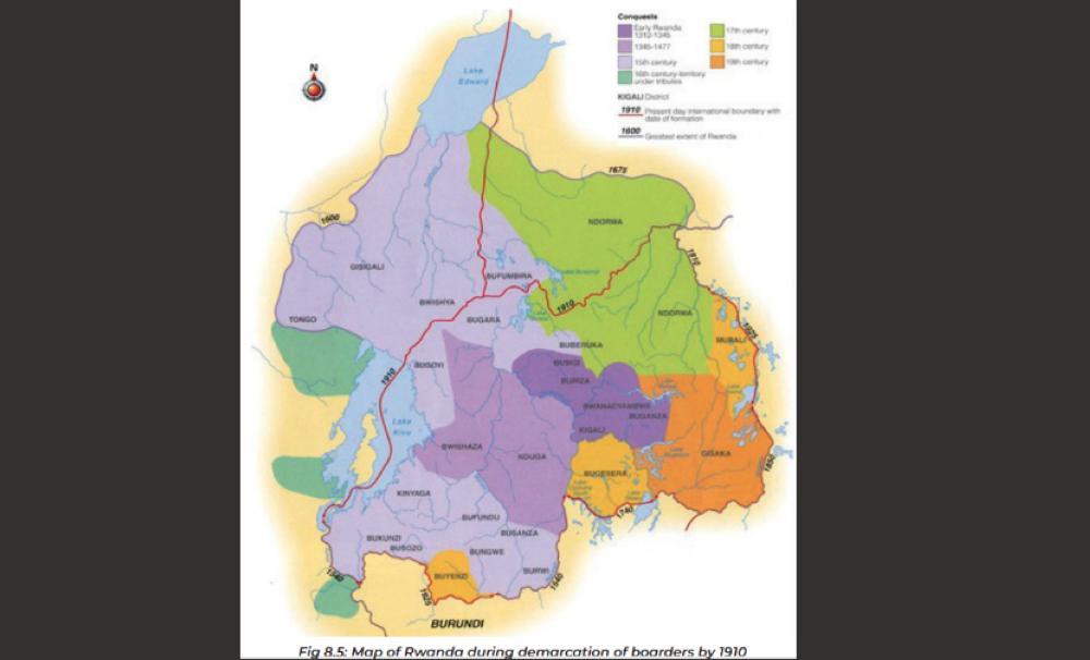
Africa-Press – Rwanda. Contrary to the widespread belief that pre-colonial Africa was entirely without borders, African kingdoms including the Kingdom of Rwanda had clearly defined territorial boundaries. Rwanda, in particular, shared borders with several neighbouring kingdoms, including Burundi, Karagwe, Buganda, and others.
This commentary does not seek to contest Rwanda’s internationally recognised borders today. Rather, it offers historical context to help inform debates particularly those that deny that Rwanda lost parts of its historical territory to what is now the Democratic Republic of Congo (DRC) and Uganda.
This denialist narrative has been popularised by two prominent Congolese historians, Thomas Ruhaka and Prof. Tshibangu Kalala.
Ruhaka, for instance, claimed that Gisenyi and Cyangugu were originally part of the DR Congo and only came under Rwanda’s control in 1910. This overlooks the fact that during the 1885 Berlin Conference, those regions were assigned to the Belgian Congo, but Germany laid claim to them in 1896.
By 1910, the German claim prevailed, and Gisenyi, Cyangugu, and part of Lake Kivu were returned to Rwanda.
Even so, while those areas were returned, Rwanda still lost significant territory during colonial demarcation. About 124,553 square kilometers in the areas now known as South and North Kivu were annexed to the DR Congo, while an additional 17,715 square kilometers were incorporated into Uganda.
Many intellectuals argue that Africa had no borders before 1885, when colonial powers drew lines during the Berlin Conference. But a more accurate view would be that Africa had ethnically and culturally defined boundaries. The Kingdom of Rwanda, like many others, had borders that its kings sought to preserve—until colonial disruption.
Two key figures in this effort were King Ruganzu II Ndoli and his grandson, King Kigeli II Nyamuheshera.
Ruganzu II Ndoli and the foundation of Rwanda’s borders
According to historical research—such as Ben Karenzi’s work “Analyzing the Negative Effects of the Demarcation of Rwanda’s Frontiers by Colonial Powers on Kinyarwanda-speaking Congolese in Eastern DRC”—the first Rwandan border was established around 1510 by Ruganzu II Ndoli.
Ndoli’s early life was shaped by political intrigue. His father, fearing for his life, sent him to be raised by his aunt Nyabunyana in Karagwe. This precaution proved wise; the kingdom was overrun by King Nsibura I Nyebunga of Bunyabungo, who killed King Ndahiro II Cyamatare—Ndoli’s father—and other royal family members.
After 11 years of occupation, Ndoli returned to Rwanda, led a military campaign, and reclaimed the kingdom. Following his coronation, Ruganzu II began expanding and re-establishing Rwanda’s territory, reclaiming areas such as Burwi of Ndara, Ruhande of Mpandahande, Bisi of Huye, Bungwe, and Bugara.
He made his first official residence in Kiziguro, Gatsibo—where he was enthroned—and a second in Ruhashya, Mara. His military base was established in Mwugariro, Kigeme in present-day Gikongoro, from where he launched a campaign to retake Bunyabungo.
Oral tradition recounts that Ruganzu, alongside his general Muvunyi wa Karema, vowed to kill King Nsibura II Nyebunga. Muvunyi succeeded in killing Nyebunga. Ruganzu then advanced further, conquering all of Bunyabungo up to the Lua River, which came to be known as Lua Rwanda.
When German colonialists arrived there, they marked the location as the border between Rwanda and the Belgian Congo, labeling it Lua Ruanda.
Kigeli II Nyamuheshera and Northern Expansion
Ruganzu’s grandson, Kigeli II Nyamuheshera, built upon his predecessor’s conquests. He first stabilised regions like Bukunzi and Busozo (now part of Rusizi District), as well as Bunyabungo. Local chiefs retained their positions but were required to pay tribute to Rwanda’s king, thereby acknowledging its sovereignty.
Nyamuheshera then pushed north, seeking recognition from the chiefs of Kamuronsi, Buhunde, Buzi, Gishali, Tongo, Masisi, and Rutshuru in what is now North Kivu. His campaign stopped at an impenetrable forest, likely the Bwindi Forest.
According to oral accounts, he told his generals they had reached the end of the inhabited world by Rwandans. Thus, the forest beyond Tongo came to represent the northern boundary of the Kingdom of Rwanda.
Turning further north, Nyamuheshera led campaigns around Lake Rwicanzige (modern-day Lake Edward), including regions such as Kigezi, Bushengero, and Busongola. At Busongola, however, he was told it was the birthplace of the ancestral spirit Lyangombe, and tradition forbade Rwandan kings from attacking that land.
Respecting this, Nyamuheshera halted his campaign there and established Rwanda’s northwestern boundary at Urutare rwa Kabasha (Kabasha Rock).
These campaigns by Ruganzu II and Kigeli II reflect the deliberate efforts of Rwanda’s monarchs to define and defend their kingdom’s borders well before colonial powers arrived. These were not arbitrary lines, but culturally and politically significant boundaries recognised by both rulers and subjects.
Source: The New Times
For More News And Analysis About Rwanda Follow Africa-Press


