
Africa-Press – Rwanda. Rubavu District has unveiled an ambitious land use master plan that will guide development through 2050, reshaping the district into a modern urban and tourism hub.
The plan, gazetted in August, will inform decision-making for government agencies, private investors, NGOs, and civil society, ensuring coordinated use of land in both urban and rural areas.
The New Times looks at key projects to transform the city.
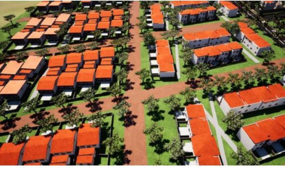
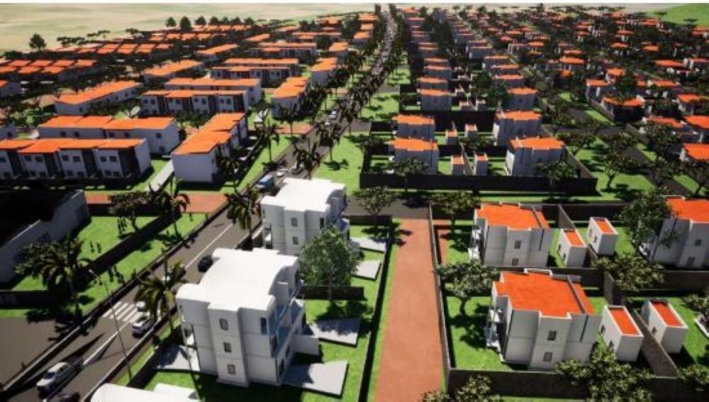
Housing expansion
According to the land use master plan, by 2050 Rubavu District will host 211,625 dwelling units, of which 125,000 will be in Rubavu Secondary City, 6,625 in urbanised rural centres, and 80,000 in rural settlement sites.
In urban areas, based on projections, Rubavu District will have 190,597 dwelling units by 2050 as people move from rural areas to urban areas.
Modern transport hub
A new transport terminal is planned opposite the High Court in Rubavu Secondary City, on a 0.78-hectare site currently used for residences and parking. Once developed, it will serve as the city’s main bus terminal, complemented by nearby retail spaces.
The local government has identified the area as a potential site for a new transport hub based on land availability and proximity to the city centre along the arterial road.
This new bus terminal will function as the main bus terminal of the city, in addition to the existing bus terminal along Market Street.
Car-free and pedestrian-friendly zones
The street north of Rubavu Market is not pedestrian friendly due to vehicles parked along it and obstacles on the footpath. The street lacks vibrancy and is unattractive for outdoor activities.
Considering the views towards Rubavu Mountain, the 200m long street will be converted into a car-free commercial street with vibrant commercial and cultural activities for both locals and tourists.
The proposed themed pavement and public art will represent the culture and identity of Rubavu. Rubavu High Street will contribute to a refreshed image of the city, especially as streets are important public spaces and iconic gathering places for residents and visitors.
The greenfield site strategically located between the waterfront and Gisenyi Catholic Parish does not have significant commercial activities to attract international tourists. The local government is considering converting one section of the waterfront into a car-free pedestrian boulevard. The site covers 2.0 ha.
The waterfront project will create a main focal point, an events’ venue and a tourist destination in Rubavu. The project will include hotels, a performing arts centre, commercial developments, a pedestrian promenade next to the waterfront park and Rubavu Waterfront Square for events and festivals.
Additionally, the road from Kivu Serena to Gorilla Hotel will be reserved as a car-free zone to encourage outdoor, environmentally friendly activities such as walking, jogging and cycling.
Cycling facilities
Provision of bicycle lanes and convenient bicycle parking in the city centre and at destinations will attract more cyclists and promote Rubavu as a green transport city.
High pedestrian activity zone
For areas like parks and recreational facilities, a pedestrian-only street will be established. The street will have a positive impact on the quality of the urban environment, and provide an attractive space for non-motorised transport users.
With pedestrian facilities, benches, paths, street lighting and greenery, the safety of non-motorised users will be enhanced.
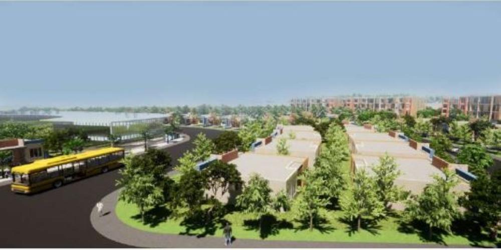
Coastal park project
Today, the waterfront area lacks commercial activities and vibrancy except during organised events such as music festivals. The park consists of a beach and a landscaped area.
During events, the road is filled with parked cars due to the lack of car park facilities. The park is 1.9 km long (0.8 km beach).
The waterfront is expected to be rejuvenated by adding active and vibrant uses. The concept is to develop pedestrian boardwalks and viewing decks that optimise the exceptional lake views.
Public art, food and beverage facilities will be located at key nodes along the park to give each area a distinctive character. Programmes including a marina and a botanical garden will create a new destination for various tourism and income groups. Gisenyi Public Beach will also be developed.
Rubavu mountain as tourist destination
Redevelopment of existing hillside developments along Rubavu Mountain will be carried out. Mount Rubavu is a great asset for the city, for both locals and tourists.
Currently, there is no clear view or direct access between the city centre and the mountain due to hillside developments. The site, strategically located at the end of the proposed Rubavu High Street, covers 0.5 ha and contains residential developments.
Kabumba urbanised centre
Kabumba, historically a trade hub, will be developed into a modern “rurban” centre with a cultural centre, youth facilities, and an upgraded market. An industrial park is also planned in Muhira to attract investment and create jobs.
A youth centre and a multipurpose hall will also be constructed to cater for the community.
The existing market will undergo a comprehensive upgrade into a contemporary shopping complex, facilitating services for both agriculture and non-agriculture-based products, as well as light industries, with emphasis on handcrafted products.
A new commercial centre will be established along the district roads near Mudende Sector, enhancing commercial interactions and serving nearby settlements with emphasis on agriculture-based products.
Industrial park
The establishment of an industrial park zone at Muhira aims to promote economic growth and attract industries. This designated zone will provide infrastructure and land for industrial activities, creating jobs and stimulating economic development.
Touristic zone
The district land use master plan identifies a touristic zone around Lake Kivu, recognising its potential. This zone emphasises the development of tourist facilities, accommodation, recreational areas and amenities to attract visitors and promote tourism as an economic driver.
Cross-border market and mixed-use areas
The plan includes cross-border markets at Busasamana and Rubavu sectors and the development of other mixed-use areas within the district.
Water port
The land use plan recognises the importance of water ports, proposing one at Nyamyumba Sector near Lake Kivu, alongside other infrastructure to support development, transportation and connectivity.
These include roads, ports, terminals and transportation hubs that facilitate the movement of goods and people, enhancing regional connectivity and economic development.
Protected zone
In 2021, Rubavu experienced one of its worst earthquakes, magnitude 6.4, caused by the eruption of Nyiragongo Volcano in the DR Congo. The earthquake left a fissure line stretching from Goma city up to Lake Kivu.
The fracture zone ranges between 60m to 80m in shallow areas and 120m to 250m in deeper portions. To protect lives and households, a protected zone (green space) has been proposed in the area to prohibit future development and structures.
A view of an artist’s impression of Kabumba urban design
According to the land use master plan, by 2050 Rubavu District will host 211,625 dwelling units, of which 125,000 will be in Rubavu Secondary City, 6,625 in urbanised rural centres, and 80,000 in rur
The plan, gazetted in August, will inform decision-making for government agencies, private investors, NGOs, and civil society.
For More News And Analysis About Rwanda Follow Africa-Press


