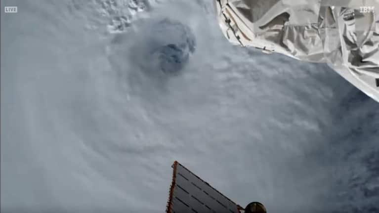
Africa-Press – Mauritius. February may be a quiet time for tropical cyclones north of the equator, but the southern hemisphere is bustling with activity. Cyclone Freddy, the strongest storm to form anywhere on Earth in 2023, is on the doorstop to Category 5-equivalent strength — and is making a run toward Madagascar.
Located about 1,500 miles south of the southern tip of India, it’s churning through the Indian Ocean as it drifts westward at about 14 mph. According to the Joint Typhoon Warning Center, maximum sustained winds are around 155 mph — 2 mph shy of the threshold for Category 5.
In the days ahead, it’s expected to swirl just south of the Mascarene Islands, its core dodging Mauritius and Réunion Island. Both islands could face heavy rainfall, but the bulk of the wind should truck on toward Madagascar.
The risk is increasing for dangerous coastal surge, flooding inland rains and strong, damaging winds, with interests in Mozambique also closely monitoring the storm. Freddy now
As of Thursday morning Eastern time, winds in Freddy’s eyewall — a ring of intense thunderstorms and extreme winds surrounding a tropical cyclone’s center — were pegged at 155 mph, with gusts in the 190 mph range.
The violent winds were present only over the open ocean, but concern is growing over Freddy’s future. On satellite, Freddy resembled a meteorological buzz saw.
A hollowed-out eye can be spotted with little effort, representing where hot, dry air was punching downward from aloft, carving a void in the middle of the storm. That marked an oasis of calm, around which the tightly coiled eyewall was wrapped.
“Satellite imagery depicts a well-defined and highly-symmetric tropical cyclone with a 7 [nautical mile wide] pinhole eye,” wrote the Joint Typhoon Warning Center in an online bulletin.
Microwave satellite data, which is able to penetrate through cloud cover and garner an “under the hood” perspective of the storm, noted one solid ring of convection — or shower and thunderstorm activity — about the center.
Beyond that “central dense overcast” region, or regime of thick cloud cover and rain, there was little in the way of spiral rain band activity. That qualifies Freddy as an “annular” cyclone — meaning it resembles a ring, a tire or a hoop.
On the storm’s periphery, high, thin cirrus clouds — whips of ice crystals aloft — depicted Freddy’s outflow, or high-altitude exhaust. That’s a sign of a healthy storm.
Where Freddy is going Freddy is expected to maintain intensity over the next 12 to 24 hours as it continues westward. It’s nestled beneath a pocket of upper-level “divergence,” or spreading in the upper atmosphere.
That generates a vacuum-like effect that encourages the air below to rise, allowing Freddy to maintain strength. Disruptive shear, or a change of wind speed and/or direction with height, is present to the south of Freddy.
It has also been fending off dry air aloft, which, if entrained into Freddy’s circulation‚ could weaken the storm’s structure. For now, the Joint Typhoon Warning Center writes “it has demonstrated a proclivity for cocooning itself and resisting the shear and dry environment that surrounds it.
” Freddy is expected to slowly lose some strength, but should still remain a powerhouse storm through early next week. By then, the center warns it should have winds of around 130 mph, qualifying it as the equivalent of a Category 4 hurricane.
Around then, it should be sideswiping Mauritius and Réunion Island, bringing tropical storm-force winds and 3 to 6 inches of rain. Weather models then suggest Freddy should weaken on approach to southeastern Madagascar, but could still strike at hurricane strength.
In addition to winds of 75 to 100 mph or more, a hazards surge (potentially on the order of six feet or more) and 8 to 14 inches of rainfall are likely.
It’s too early to iron out any potential impact to Mauritius. Historical risk About 11 percent of the world’s tropical cyclones form in the southwest Indian Ocean.
An average of nine tropical storms form each season, five of which typically reach hurricane strength. Cyclone season in the southern Indian Ocean begins to perk up in October, and peaks in January before tapering off in March.
Storms generally drift west-southwest before recovering more to the southwest before dissipating. This leaves Madagascar at a significant risk; an average of 10 tropical depressions (tropical low pressure systems with winds less than 39 mph) strike the island nation annually.
For More News And Analysis About Mauritius Follow Africa-Press


