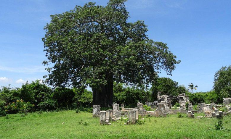
Africa-Press – Tanzania. KILWA Kisiwani is an island, national historic site and hamlet community located in the township of Kilwa Masoko, the district seat of Kilwa District in the Tanzanian region of Lindi in southern Tanzania.
Kilwa Kisiwani is the largest of the nine hamlets in the town of Kilwa Masoko and is also the least populated hamlet in the township with around 1,150 residents.
At its peak in the Middle Ages, Kilwa had over 10,000 inhabitants. Since 1981, the entire island of Kilwa Kisiwani has been designated by UNESCO as a World Heritage Site along with the nearby ruins of Songo Mnara.
Despite its significant historic reputation, Kilwa Kisiwani is still home to a small and resilient community of natives who have inhabited the island for centuries. Kilwa Kisiwani is one of the seven World Heritage Sites in Tanzania. Additionally, the site is a registered National Historic Site of Tanzania.
Geography
Kilwa Kisiwani Island lies 9 degrees south of the equator. The island is 23 km (14 mi) in circumference and the total land area is 12 km2 (4.6 sq mi). On the west part of the island is the Mavuji River estuary. On the south part of the island lies the Sagarungu sound and to the east lies the Indian Ocean.
Economy
The island is located with the Kilwa Masoko township authority. The main economic activities on the island are cultural tourism, fishing and subsistence agriculture. Economic growth is limited due to the island’s isolation.
Historical significance
Kilwa Kisiwani is an archaeological Swahili City State site located along the Swahili Coast on the Kilwa Archipelago. Recent excavations and Carbon-14 dating of the site have confirmed its founding at the start of the 9th century CE.
Historically, it was the centre of the Kilwa Sultanate, a medieval Swahili sultanate whose authority at its height in the 13th, 14th and 15th centuries stretched the entire length of the Swahili Coast. The seasonal wind reversals affected trade.
In 1331 CE, Moroccan traveller and scholar Ibn Battuta visited Kilwa and described it as one of the most beautiful cities in the world.
The Swahili cemeteries are located on the edge of the town, which is common for the Swahili region and large, open spaces were likely used for social gatherings. An important city for trade, around the 13th century there were increased fortifications and a greater flow of goods.
Marine resources are abundant and used for food, supplemented by the surrounding land. Due to the impact the sea had on Kilwa, including marine resources and trade opportunities, the archaeological investigation of the harbours and ports is considered to be of high importance.
Ancient DNA analysis
A study by Brielle et al in 2023 completed ancient DNA analysis of several samples from the ruins of Kilwa. Ancient DNA (aDNA) analysis was completed for 80 individuals from six medieval and early modern (1250–1800 CE) coastal towns and an inland town after 1650 in order to determine the proportions of “African-like, Persian-like and Indian-like” DNA sequences.
More than half of the DNA of many of the individuals from coastal towns originated from primarily female ancestors from Africa, with a large proportion, sometimes more than half of the DNA coming from Asian ancestors.
The Asian ancestry includes components associated with Persia and India, with 80 to 90 per cent of the Asian DNA originating from Persian men. Peoples of African and Asian (predominantly Persian) origins began to mix by about 1000 CE. Samples were taken from two boxes of human remains located in the British Institute in Eastern Africa (BIEA) in Nairobi, originally excavated in the 1950s and 1960s by Chittick.
After 1500, the sources of male Asian DNA became increasingly Arabian, consistent with increased interactions with southern Arabia. From medieval times until the modern day, subsequent interactions with different Asian and African people have changed the ancestry of the present-day people living on the Swahili coast compared to the medieval individuals whose DNA was sequenced.
Potentially dating from 1300- 1600 (more precise radiocarbon dating techniques were unable to be completed in time for these samples), analysis was completed of the individuals’ mitochondrial DNA (mtDNA), autosomal DNA, Y chromosome DNA and X chromosome DNA.
Analysis of mtDNA in the individual, demonstrating maternal ancestry patterns, showed a L* haplotype. The L* haplotype is predominantly found in presentday Sub-Saharan African populations. Y chromosome analysis, demonstrating paternal ancestry patterns, showed that the individual was carrying the J2 haplotype, a DNA pattern found in Southwest Asian or Persian individuals.
X chromosomes, containing larger maternal influence, were compared with the 22 autosomal chromosomes, which contain equal maternal and paternal influence. X chromosomes contained more indicators of African ancestry compared to the autosomal DNA, further adding to evidence of African ancestry on the maternal side and Persian or Southeast Asian ancestry on the paternal side.
Preservation
In 2004, Kilwa Kisiwani was inscribed on UNESCO’s List of World Heritage in Danger. There is a serious rapid deterioration of the archaeological and monumental heritage of these two islands due to various agents like erosion and vegetation.
The eastern section of the Palace of Husuni Kubwa, for example, is progressively disappearing. The damage to the soil caused by rainwater wash is accentuating the risks of the collapse of the remaining structures on the edge of the cliff.
The vegetation that proliferates on the cliff has limited the progression of the rain-wash effect but causes the break-up of the masonry structures. A team of CHAM volunteers ensured the protection of the ancient city between 2001 and 2007.
The World Monuments Fund included Kilwa on its 2008 Watch List of 100 Most Endangered Sites and since 2008 has been supporting conservation work on various buildings. In 2014 it was removed from the list.
Between 2005 and 2009, the Zamani Project documented some of the Swahili ruins on Kilwa Kisiwani with terrestrial 3D laser scanning. The structures documented include: The Gereza (prison); the Great Mosque; the Husuni Kubwa; the Makutani Building and the Malindi Mosque. Some of the 3D models, a panorama tour, elevations, sections and plans are available on www.zamaniproject.org.
Historic buildings
Great Mosque
The earliest section, likely the northern prayer hall, dates back to the 12th century. Built between 1131 and 1170 (according to historical records), this rectangular structure showcased typical construction of the period. The load-bearing walls were built with square coral limestone blocks and three symmetrical entrances with vaulted ceilings provided access. Uniquely for mosques in the area, the flat roof was supported by nine hexagonal columns made from single tree trunks.
Archaeological discoveries have shed light on the original design. The roof, constructed from coral tiles embedded in mortar, featured decorative concentric circles. Traces of red paint suggest the mosque may have been adorned in red and black, adding a touch of colour.
Later additions and renovations
The early 14th century saw a major expansion under Sultan al-Hasan ibn Sulaiman, who also constructed the nearby Palace of Husuni Kubwa. This extension likely included the grand dome described by Ibn Battuta during his visit in 1331.
The mihrab, the niche indicating the direction of prayer, appears to be a later addition. Its design; a pointed arch, capitals, pilasters, friezes and a fluted half-dome vault differs from the original structure. Interestingly, protruding coral blocks suggest the presence of a fixed wooden minbar and traces of oblong niches within the main niche hint at a possible Shirazi influence. These elements may have been incorporated from an earlier design during renovations.
Water management system
The western section of the mosque housed the ablution area, essential for worshippers to perform ritual cleansing before prayers. Restoration efforts unearthed an intricate network of water channels made from baked clay, providing insights into the mosque’s well-designed water management system.
Palace of Husuni Kubwa
Husuni Kubwa (the Great Palace), situated outside the town, was an early 14th-century sultan’s palace and emporium. Other defining features include causeways and platforms at the entrance of the Harbour made from blocks of reef and coral nearly a meter high.
These act as breakwaters, allowing mangroves to grow which is one of the ways the breakwater can be spotted from a distance. Some parts of the causeway are made from the bedrock, but usually the bedrock was used as a base. Coral stone was used to build up the causeways with sand and lime being used to cement the cobbles together. Some of the stones were left loose.
The Palace of Husuni Kubwa is another prominent structure in Kilwa. The majority of the palace was erected in the 14th century by Sultan al-Hasan ibn Sulaiman, who also built an extension to the nearby Great Mosque of Kilwa, although portions may date back to the 13th century. For unknown reasons, the palace was inhabited only for a brief period of time and abandoned before its completion.
In true Swahili architecture style the structure was built out of coral stone on a high bluff overlooking the Indian Ocean. It consists of three major elements: A south court, used primarily for commerce; a residential complex including over one hundred individual rooms; and a wide stairway leading down to a mosque on the beach.
Other notable features include a pavilion, which likely served as a reception hall and an octagonal swimming pool. All of Husuni Kubwa spans across approximately two acres.
The coral rag was set in limestone mortar and cut stone was used for decorative pieces, door jams and vaults. The rooms were about 3 metres tall. The roof was made from cut limestone blocks laid across cut timbers and the floors were white plaster. The main entrance to Husuni Kubwa is from the shore.
Husuni Ndogo
Husuni Ndogo (“Little Palace”) is built from coral rubble and limestone mortar. The rectangular enclosure wall surrounds the complex and at each corner stands a tower. The foundations extend two metres below ground level.
It appears to have been built as a fort, but the exact purposes and uses are somewhat unknown. There is some evidence that it, for at least a time, was used as a mosque. Architecturally, it appears to be different from other buildings along the coast, resembling buildings constructed under the Caliphs of the Umayyad at around 661-750 CE. However, whether or not the structure is related or even dates to the Arabic buildings remains uncertain, though it seems unlikely.
Gereza Fort
The Gereza Fort (also called the Arab Fort) is situated between the Makutani Palace and the Great Mosque. There are some evidences that the original structure was Portuguese, while the present form of the fort is of typical Omani forts.
For More News And Analysis About Tanzania Follow Africa-Press


